Government
Working specifically on the customisation of the software, the team are able to create situational awareness that fits specific national infrastructure requirements. Operating across mobile, VHF and satellite networks, the system allows information and intelligence to be accessed securely. Intelligence can be shared and enhanced across networks with users being rapidly assigned and re-assigned to tasks, creating truly agile networks, and breaking down traditional organisational silos.
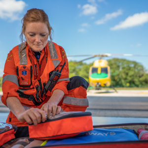
More than 100,000 operations have been conducted with Airbox in a single year, marking a proud milestone for the company and showing the level of trust placed in Airbox by our customers. No other operational situational awareness platform in the UK has achieved this. Airbox Systems has been at the forefront of situational awareness for over a decade, with the clear mission to save and protect lives in the emergency response field. During the last 12 months Airbox has been used on over 100,000 separate operations across police, fire, ambulance and coastguard operations. This has been an unprecedented and testing year for the emergency community, Airbox is very proud to have played a small role in assisting all of those that have played their part in helping those in need.

Enabling our users to work faster and smarter
 40%
Increased force multipler
40%
Increased force multipler
 <30%
Critical National Infrasturcture reduces terrorist threat
<30%
Critical National Infrasturcture reduces terrorist threat
 60,000
Ensuring the safety of over 60,000 first responders
60,000
Ensuring the safety of over 60,000 first responders
ResilienceDirect™ is owned by the Civil Contingencies Secretariat within the British Cabinet Office and developed in partnership with Airbox Systems. Its aim is to improve the sharing of information within the resilience community across all organisational and geographic boundaries. ResilienceDirect™ exists to improve the way in which the British nation plan for and respond to incidents by providing software tools to the community free of charge.
Functionality for first responders
ResilienceDirect™ provides a secure online mapping environment utilising the Ordnance Survey’s powerful AddressBase Premium data system, which provides information on over 40 million unique addresses within the UK. Users can overlay and interrogate data from Ordnance Survey, Environment Agency, Met Office, infrastructure owners, members of the community and other sources. Harnessing the power of the community to get access to better information and enable informed decisions. Custom maps annotated with notes and information can be rapidly created either for ongoing events or as templates to be used for contingencies.
Plans can be securely shared with other members of the resilience community, including a briefing mode which allows users to conduct remote briefing, providing a single version of the truth and quick access when it is needed most.
“ResilienceDirect has transformed the way that local resilience forums share work and good practice, dramatically improving information-flow which is so critical in a major incident.”
Paul Netherton, ACC Devon And Cornwall Police